
- Home
- Search
- Images
- Species Checklists
- US States: O-Z >
- US National Parks
- Central America
- South America
- US National Parks
- Southern Subpolar Region
|
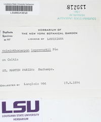
Helminthocarpon leprevostii Fée
 |
|
|
Family: Arthoniales_family_incertae_sedis
[Graphis leprevostii (Fée) Mont.] ]") Frank Bungartz |
Essai Crypt. Exot., Suppl. (Paris): 156 (1837) Thallus corticolous, rarely lignicolous, not delimited by a distinct prothallus, in contact with other thalli often forming a thin brown line; thallus surface pale beige, corticate, smooth and shiny; medulla white, densely packed with minute crystals that dissolve completely in KOH, lacking calcium oxalate crystals (not forming colorless, needle-shaped crystals in 25% H2SO4); ascomata developing as short, broad, swollen lirellae with a thick outer thalline layer that at maturity breaks open along a wide, irregular central slit; exciple flanks strongly carbonized, but buried below thick thalline layer; subhymenium and hypothecium hyaline to pale brown; hamathecium of strongly ramified and anastomosing paraphysoids that closely envelop the asci, KI+ blue; asci bitunicate-fissitunicate, cylindrical to narrowly clavate, basally tapering into a stalk, immature ascus wall strongly thickened, with maturity differentiating into two distinct layers (ca. 20-25 μm wide, basally thinner, thickened towards the apex), KI+ pale blue throughout, at the apex occasionally with a minute, KI+ deep blue ring, ocular chamber indistinct or absent; ascospores hyaline, K-, elongate fusiform, muriform with curved septa, (89-)120-150(-165)×(22-)26-44(-62) μm, 8 per ascus; conidiomata not observed. Spot tests and chemistry: P-, K-, C+ red, KC+ red; UV- (pale yellowish green); medulla ILugol’s-; lecanoric acid. Distribution and ecology: Pantropical; new to Galapagos, moderately common throughout the dry and lower transition zone on bark of native and endemic trees, especially Bursera graveolens, Pisonia floribunda and Cordia lutea; mostly in semi-shaded to shaded and ±sheltered habitats, rarely also in moderately sunny and ±exposed sites. Specimens examined: Ecuador: Galapagos: Isla Española, along S-coast of the island, SE of Punta Suárez, ca. 500 m inland from coast, 1°22’57”S, 89°43’8”W, alt. 133m, dry zone, on bark, 10-Nov-2010, Bungartz 8972 (CDS 45790); trail from Bahía Manzanillo on the N-coast of the island to the highest point, 1°22’19”S, 89°42’7”W, alt. 125m, dry zone, on bark, 11-Nov-2010, Yánez 1686 (CDS 45569). Isla Floreana, Cerro Pajas, inside the crater, 1°17’49”S, 90°27’23”W, alt. 379 m, humid zone, on bark, 12-Jan-2011, Bungartz 9285 (CDS 46511); trail from Black Beach to highlands, on bark, 25-Apr-1976, Weber s.n. (COLO 294611, L-62910); trail going to Post Office Bay off the dirt road between highlands and Puerto Velasco Ibarra, cliff at NE-side of trail (mirador), 1°17’4”S, 90°26’37”W, alt. 365m, on bark, 25-Jan-2011, Yánez 2113 (CDS 46578). Isla Pinta, along the trail up to the summit from the S-coast, 0°34’9”N, 90°44’59”W, alt. 252m, transition zone, on bark, 25-Feb-2007, Bungartz 5712 (CDS 33350); 0°34’5”N, 90°44’57”W, alt. 237 m, transition zone, on bark, 28-Feb-2007, Bungartz 5905 (CDS 33582); Bungartz 5922 (CDS 33599). Isla San Cristóbal, SW foothills of Media Luna, inland from the NW-coast of the island along the trail from Galapagera to Media Luna; bottom of small crater to the NW of Media Luna, 0°43’53”S, 89°18’57”W, alt. 124m, dry zone, on bark, 22-Apr-2007, Bungartz 6239 (CDS 34451). Isla Santa Cruz, Bellavista, along road, 0°41’35”S, 90°19’27”W, alt. 200m, humid zone, on bark, 30-May-2005, Aptroot 63307 (CDS 30047); farm of Don Cabrera between Bellavista and Cascajo, ca. 1 km W of Cascajo, 0°40’39”S, 90°17’21”W, alt. 249m, humid zone, agricultural area, on wood, 16-Jun-2010, Yánez 1491 (CDS 44921); on the North side of the island, along the dirt road to the ash quarry Mina Granillo Rojo, 0°36’56”S, 90°22’3”W, alt. 570m, transition zone, on bark, 23-Feb-2006, Aptroot 64570 (CDS 31142), Aptroot 64556 (CDS 31128). Isla Santiago, along the trail from Bucanero to Jaboncillos, ca. 1 km below the summit, Cerro Gavilan, 0°11’45”S, 90°47’20”W, alt. 680m, transition zone, on bark, 22-Mar-2006, Aptroot 65449 (CDS 32037), Bungartz 4676 (CDS 28763); ca. 7 km inland from the E-coast, ± at the same latitude as Bahía Sullivan, 0°17’4”S, 90°38’18”W, alt. 192m, dry zone, on bark, 17-Jul-2006, Bungartz 5185 (CDS 29398). Isla Isabela, Volcán Alcedo, along the trail going up the E-slope, at the NW-side of the trail, 0°24’2”S, 91°2’36”W, alt. 410m, dry zone, on bark, 09-Mar-2006, Bungartz 4390 (CDS 28475); 0°24’3”S, 91°2’35”W, alt. 434m, dry zone, on bark, 09-Mar-2006, Bungartz 4405 (CDS 28490), Aptroot 64953 (CDS 31532); 0°24’7”S, 91°2’55”W, alt. 493m, dry zone, on bark, 10-Mar-2006, Bungartz 4448 (CDS 28534); 09-Mar-2006, Aptroot 64965 (CDS 31545). Volcán Sierra Negra, Las Merceditas, 0°51’58”S, 91°0’50”W, alt. 208 m, humid zone, agricultural area, on bark, 15-Aug-2008, Bungartz 8294 (CDS 40940). from: |

]")
]")
]")
")


![]()
![]()

![]()
![]()
![]()
![]()
![]()